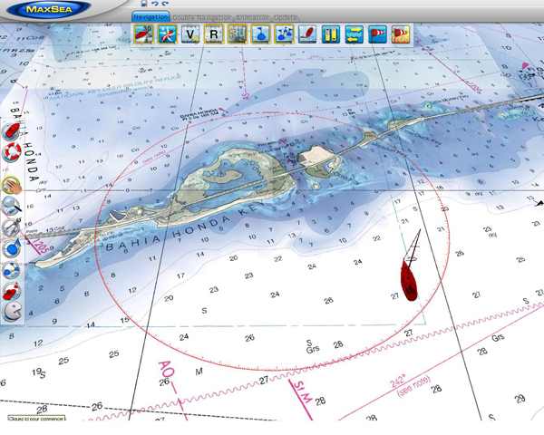
The AIS function is included as standard in MaxSea Time Zero. Any AIS receiver or transmitter can be connected to MaxSea Time Zero, allowing you to display AIS targets around your boat directly on the charts.
|
All versions of MaxSea Time Zero come with free, unlimited weather forecasts (Wind, Pressure, Waves, Could Coverage, etc) available worldwide, 24 hours a day.
In addition MaxSea Time Zero Explorer includes unlimited access to oceanic data (Sea Surface Temperature, Altimetry and Chlorophyll). Weather Forecasts and data are requested directly through MaxSea, allowing you to receive the data via e-mail or to download it directly from the Internet. When installing the software on your computer, all supported languages are also installed. MaxSea will use the language defined in the « Region & language » settings of your Operating System.
If you want to change the language in MaxSea Time Zero, open the Windows « Control Panel », select « Region and Language » and change the “location” setting. MM3D Raster Charts
Marine raster charts are produced based on National hydrographic offices’ marine cartograhy. As True digital copies, they allow to get on screen the official marine paper charts that you were accustomed to use. MM3D Vector Charts The C- map by Jeppesen vector charts are reproductions of marine cartography where data are processed and digitized in a format allowing additional information: information on buoys, lighthouses and ports, specific instructions on regulations, etc. Raster or Vector Charts It's hard to say which chart format is better than the other, the choice is often based ultimately on user habits. The paper marine chart amateurs will prefer electronic raster chart, while those who have always used vector charts will struggle to break away. Marine navigation software MaxSea Time Zero enables to download and display weather forecast and oceanic data in standard grib format directly from MaxSea Weather Wizard.
This weather tool is completely free and easy to use, giving you unlimited access to weather forecasts worldwide 24hours a day. Select a geographic coverage, data type, period of time and choose how to receive the file. MaxSea Time Zero can provide up to 16 days of weather forecast! To do this, just send a request and receive weather data either downloading directly from Internet or via Email. The received file weighs only a few kb. The built-in compression algorithm is optimized for binary data (grib format), making downloading over satellite phones and single side band (SSB) possible. Once you´ve received and opened the grib file, the data will be overlayed onto your charts. Then, you can choose to display all or some of the following weather forecast data: Wind, Waves, atmospheric pressure, clouds and rain. When selecting digital marine cartography, there are important things to consider. We give you some simple tips on how to choose wisely.
1- First of all, which electronic marine charts formats are compatible with my software?The more versatile your software is, the easier it will be to find the best and most accurate marine charts for your specific area. MaxSea’s main advantage is its compatibility with a wide range of marine chart formats:
2- Where do electronic marine charts originate?Marine Raster Charts are geo-referenced, digital images of Official Hydrographic Office and selected private navigational charts. True colour copies of the official paper marine charts of hydrographic services, raster charts are the most reliable, allowing you to display on screen the official paper marine charts that you were accustomed to use. Marine Vector Charts utilize a vector database to build the chart display. This data is stored in layers and records every nautical chart feature such as coastlines, buoys, lights, etc. These features and their attributes such as position, colour, size, shape, and others are stored in a database allowing them to be selectively displayed and interrogated. In many areas of the globe where there’s no hydrographic service, vector maps are often the only reference. 3- What is the best navigational chart format: vector or raster?Vector charts or raster marine charts? The choice is complex and raises a real debate between two schools. Hard to say which format is better than the other, and in the end the choice is often lies on user habits or personal preference. Traditional paper chart users tend to like Raster Charts, since visually these are an exact reproduction of the paper chart. Vector Charts are stored as a database and drawn on the computer or plotter screen by the software, thus the display of a Vector Chart does not resemble a paper chart. MapMedia offers a wide range of over 6000 marine raster charts restoring the accuracy and reliability of national hydrographic offices paper charts. MapMedia also produces vector charts through collaborations with the best charts editors of the market: Navionics, Jeppesen and some national hydrographic services (databases S57 for USA and Norway). MapMedia is able to provide a complete catalogue of vector charts along with marine raster charts offer. With MaxSea TimeZero Explorer you can directly connect your NavNet 3D network right out of the box! You will have full control of your NavNet 3D Radar/Chart Plotter system directly from your PC. MaxSea TimeZero Explorer integrates seamlessly with NavNet 3D via Ethernet connection. Now you can access and control valuable information from your NavNet 3D network, such as Radar Overlay, Waypoints, Routes and more directly on your PC.
|
AuthorYannis Baxevanis | Managing Director | nuova marea ltd Archives
September 2012
Categories
All
|


 RSS Feed
